Saturday, June 23, 2007

The Farne Islands - Home to Puffins and More!

The Farne Islands are a group of rocky and remote islands about two miles off the Northumberland coast in the North Sea. The Islands are preserved as part of the National Trust and are home to many species of birds. Nesting seabirds include terns, puffins, guillemots, shags, eider ducks and kittiwakes (which look like sea gulls). Grey seals also rest on the rocks of the islands.

We took a boat tour (along with a lot of other tourists!) to the islands, which lasted about two and a half hours. We saw tons of birds and seals and got to get out and walk on Staple Island to see a lot of nesting birds close-up, including puffins! I was surprised to learn that puffins nest underground. They dig burrows in the turf and pop in and out of them with their beaks full of fish. The island was covered with birds and it was a truly unique, noisy, and smelly, experience.
Puffins at the top of the rocky cliffs on one of the Farne Islands. Look closely to see a puffin taking a leap off the rock!
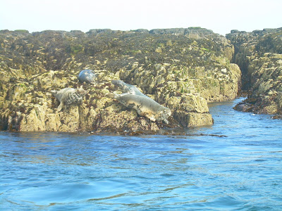
Grey seals. The tour boat got quite close to the rocks where the seals were and some dove into the water while others just raised their eyebrows at us.
Once off the boat on Staple Island we were able to see the masses of nesting birds up close. The island was roped off so you could only walk in a certain area to protect the birds (and likely to protect the visitors from falling off the cliffs!). The birds you see the most of are the guillemots, which look like penguins in their tuxedo black and white coloring, and which lay their pear-shaped eggs directly on the high rocks.
Matt gets some footage of the puffins. Note the puffin flying overhead!
Puffins around their turf burrows. As we stood and watched we could see them come in and out of their burrows, which were small holes in the ground.
Matt got this great close-up of a strutting puffin. They are pretty funny looking walking around on land, and after getting a running start and leaping off the ground they make a loud fluttering noise when they fly!
Cormorants about to feed their hungry chicks. The cormorants only nest on a few of the islands, in big groups.
Kittiwakes nesting on outcroppings in the cliffs. Look closely to see the little grey chick in the nest.
Looking out back towards the mainland from Staple Island. The specks you see are all flying birds, most of them puffins! The puffins only nest on islands with turf.
Our boat was the "Glad Tidings II". There was such a huge tide (the tide is always very large here, however with the summer solstice on the way the tides were extreme that day) that the captain had all the passengers pile into the front covered area of the boat to try to lift the props, and had to make two tries to get the boat into the harbor. He did succeed, finally, and we made our way back up the stairs and onto the wharf. On to our next adventure!

The Coast

After seeing Lindisfarne, we drove south and saw more of the coast. We walked on the beach near Bamburgh castle, where there are high dunes to walk through before you get to the sea. It reminded us of the National Seashore near Cape Canaveral in Florida. Later the same day we took another coastal walk to see Dunstanburgh Castle, which is situated up on a high cliff above the sea. We stopped near Seahouses (a kitchy coastal town where everyone is on holiday) to spend the night and planned to take a boat trip the next morning to see the Farne Islands.
Walking along the coast to Dunstanburgh Castle (we did this walk too late in the day to get into the castle).
This lamb was enjoying his prime seaside grazing real estate with a view of the castle.
The castle overlooks high cliffs where the sea crashes on rocks. We saw birds swooping down to catch fish. The drop must have been more than 100 feet. Here Matt is standing at the edge looking down.Where we stayed at Seahouses.

Our UK Road Trip Begins - Lindisfarne

We set off from Vindolanda after assuring everyone we would be back to say bye before we flew to the US, and Matt drove us northeast to the edge of the North Sea. (I was not about to attempt the "wrong side" of the road driving of which Matt has become an expert while he has been here.) We were headed to Holy Island to see the Lindisfarne priory and castle. Holy Island, or just Lindisfarne as the locals call it, is an island reached by a tidal causeway, so you must study the tide tables and be sure to cross only within the hours when it is safe, or you risk being swept away by very strong tidal currents. Just a few weeks ago a car was caught in the middle and its passengers had to be airlifted out via helicopter.The Lindisfarne Priory ruins

The Lindisfarne Priory on Holy Island was started by St. Aidan who came from Iona in the 11th century, but the current priory was begun by St. Cuthbert who decided to be a monk as a young man after having a vision of St. Aidan being lifted to heaven. St. Cuthbert went on to spread Christianity in Britain to Northumberland and southward. His bones now rest in Durham cathedral, which we visited later in our trip.The ruins of the priory are dramatic and the island is beautiful. We were very lucky to have sunny, breezy weather and no rain. For the first time I was warm and we had to stop on our walk to the castle to peel off extra socks and layers of clothing!St. Aidan says "thanks for stopping by my remote island priory! Y'all come back now!"

The Lindisfarne Castle is on high on a hill at the end of the island. To get there we walked around the coast and saw the many ships which are no longer in use and have been turned upside down and made into storage buildings. The castle is impressive and the inside is furnished and filled with an assortment of antiques and antiquities that reminded me of home. The castle was used as a holiday home for a wealthy family in the 1700s. The Lindisfarne CastleOur view looking down at Holy Island and the priory ruins from the top of the castle.

Tullie House, Carlisle

On two of the afternoons when our digging was rained out we took mini road trips to some nearby Northumberland towns. Matt took me to see the Hexham Abbey one day and we went to Carlisle another day. Tullie House is the museum in Carlisle with a combination of historical, artistic and natural history exhibits. We were especially interested in the Roman displays, where they have a lot of inscribed altars and some interactive exhibits. It was a good place to hang out on a rainy afternoon.Saddle up! Matt rides as a Roman (no reins!)

Update on Rainy Dig Week

The last week of my digging was too waterlogged to go much more in depth than what Katie and I did on the first day of the dig week. The rain was such that we only got one other day in for digging. We removed topsoil on a different area because the original bit we were excavating was too soggy and muddy to do any archaeology. So we found some bits of pottery and shoveled some dirt. One of the days was a complete washout. The other two days we stayed and helped wash pottery found earlier in the season and mark it ready to be taken down to the lab. A few samian stamps were discovered as was a bit of amphorae that had a painted decoration on part. The pictures I think say it all.


Katie and I did go to Tullie House Museum in nearby Carlisle on one of the days we were not able to dig. The museum has a collection of Roman material but also displays on the geology and nature of the north west of England and a display on the Border Reivers of the 1300-1600's. We also went for a walk in the drizzly rain and saw the last bit of standing remains of Hadrian's Wall. The walk takes you over the River Irthing on a very well done foot bridge built in 1999. Before that you had to back track and walk extra couple of miles to pick up the Wall walk again. The next two pictures show part of the Roman bridge that would have crossed the River Irthing with a road on the top. Katie is standing next to what is left of the east bridge abutment. The west abutment is under grazing land as the river has moved further west cutting into the cliff that the Wall would have come down. The last picture is taken from the top of the cliff mentioned above and looks east over the flood plain and the Wall as it comes down to meet the east bridge abutment.


Wednesday, June 13, 2007

Washed Out

Area B under water
The wall trench in Area A under water

Day two of Katie and I's week has been rained out. I took a couple of pictures to show how bad the trenches have filled up. Both Justin and Andy were amazed at the amount of water. I guess the trenches have never filled up so much in just a day. The area Katie and I are excavating is under at least 8 inches of water. Some sections from each excavation area have four feet of water which will be difficult to drain and keep drained as it continues to rain the rest of today and tomorrow.

We did find a few interesting things on our first day of digging. We found a ceramic gaming counter and a large fragment of a DEA NUTRIX statuette but no shoes, yet. The statue is a goddess mother figure that is seated in a wicker chair and has a basket of produce or a child in her arms. The statuette is most likely part of a house shrine instead of a temple. The full height would probably be around ten inches. I hope we find more of it and are able to see the whole thing.
Dea Nutrix statuette fragment

And now for Katie's blog comments!
So, yesterday was my first day of digging, and it was warm and sunny for the most part (it rained while we had lunch). Matt introduced me to all of the archaeologists he has been working with these last two months and I got to see some of the areas I had only been seeing here in photos on the blog. What Matt did not mention about the ceramic statuette fragment is that he identified it immediately when we pulled it out of the trench. I was holding a muddy piece of what looked like pottery and noticed that it was a funky shape, and Matt said, oh that is at Dea Nutrix statuette! He has got this archeology thing figured out!

Today after going to Vindolanda and checking out the entire fort underwater we went into Hexham and found me some waterproof hiking boots and wellies, as my sneakers were already soaked through just from walking around the site. The amount of rain we have gotten is amazing, but it seems to be slacking off now, so hopefully the rest of the week will be dry and we can get back to digging. Stay tuned!
Katie

Monday, June 11, 2007

Katie's Here!

Katie has finally arrived. Her flights went well although the four hour layover in Heathrow was a little taxing. We start digging tomorrow so she doesn't have much time to rest up. At least it's easy digging- no topsoil to grind through.

Hi everyone! I am happy to be here and I will keep you updated on this my first week, and Matt's last week, of digging at Vindolanda. Perhaps this year I will find a shoe! We will do some more posts this week, then next week we head out on our road trip to see parts of the coast and we might not have Internet every day.

So watch this space!
Katie

A Morning Walk at Vindolanda


I went for a walk around Vindolanda for Sunday morning. There is a public footpath along the creek near the museum and then another path along the southern boundary of the property that leads from the creek to the west, uphill. The walk along the southern edge of Vindolanda gives a different perspective to the view of the fort and settlement. A deep gully that has constant water flow for most of it creates a natural border that would be difficult to cross without a bridge or causeway. A stone causeway was discovered during excavation work in the early 70's that may have been a crossing point in Roman times reused by later farmers and the like. The ground rises as you head west until the gully gives out and you are just beyond the western limits of the Vindolanda property. The way the land lays further west of where excavations are already progressing in Area B lends to more archaeology awaiting discovery. But now that area is the home of a herd of cattle that have to share their field with walkers like myself and crazy offroad motor bikes that use a north/south path as a way to get cross country. And it is legal. They are noisy, dusty, and often spook the cattle. I have been digging on a Saturady when a whole group of bikes roars by and it destroys the natural setting of the area. It is a shame that the bikes are allowed to tear through the fields but not much can be done about it. While on my hike around Vindolanda I was able to take a few pictures of the lone deer that frequents the fields. There were a couple of other deer a few years ago, one still roaming around on just three legs. The three legged one seems to not be around anymore, though. The other picture is of a couple of horses in a small field near the museum that were taking a break. I guess they even thought 70F must be pretty hot!

I had to put this picture in to show all those volunteers who helped dig six feet down to find the stone fort one wall for the last three weeks had the more difficult work. By the end of yesterday Area A's crew had found the continuation of the wall lying just below the topsoil! It is six course high at its greatest and seem to show a hint of a turn in roughly the area where Robin had us place his marker. There isn't much more room to dig to the north as the water and telephone lines cross the area. It is great to see the wall show so quickly and I hope to see lots more of it by the end of the week. I'll be stopping by daily to get the update.

Saturday, June 9, 2007

Archaeology in Area B


I finished my first of two weeks back on Justin's crew. The area of archaeology has grown quite a bit since I was last on his crew some five weeks ago. The area opened and under excavation has doubled in those five weeks. The picture I have first up is an overview of the majority of archaeology open in Area B. Everything on the far side of the baulk running left to right across the picture has been excavated and will be backfilled in the upcoming weeks. The section most everyone is working in is nearest the bottom edge of the picture where a number of ditches seem to be converging. The big question at the moment is whether the ditches are all man made or is at least one a natural gully that was used by the populace to help drain away water and waste? I'll be interested to read about the conclusion in the eventual report.
This week glass and ceramic gaming counters were prevalent in one section of the new area opened which quickly got the nickname "Las Vegas of Vindolanda". Three more shoe soles and a piece of tent with cord was found in the largest of the ditches under excavation this week. Two of the shoe soles still had some hobnails attached. One of those was small, sized for a child maybe 8-9 years old. I haven't found much as I have been helping to finish out areas so they could be recorded and closed out for excavation. I was able to get my hands dirty using the total station to record the good bits onto an auto CAD plan. Archaeology isn't all just digging fun!
Next week Katie will be here and we will be sharing a section excavating one of the ditches 9far left and lower left of piucture). I found a bit of a samian bowl in the ditch fill which had a piece of the stamp which was was exciting as I have not found a pottery stamp yet. Pottery stamps can be just as important as coins for dating evidence for the levels of archaeology we dig through. Hopefully more good stuff will show up next week.

Sunday, June 3, 2007

Another Drive About


I took another drive today. This time I went to Bewcastle and Lanercost Priory. Bewcastle is a ruin set on a motte within the ditches of a Roman fort. The Roman fort was first built in the 120's AD and abandoned when the Antonine Wall was built in Scotland in the 140's AD. The fort was recommisioned in the 160's AD when the Roman frontier was pulled back to the Hadrian's Wall area. Bewcastle is north of the Wall near the present day English/Scottish border. It is a strange design for a Roman fort as it is not a classic playing card style similar to Vindolanda. Instead, the fort makes use of natural plateau which is hexagonal in shape. The platform can be seen as can the ditches but there is no Roman remains on display. The fort platform is now used by a farm, a church, and the ruin of Bewcastle. At the church most of an Anglo-Saxon carved stone cross stands. The first picture is of the cross and is the relief where three persons are represented and Anglo-Saxon writing (more like runes) is evident. The cross dates from the late 600's AD. The other two pictures are the remains of Bewcastle. I had to share with sheep who had taken up within the gatehouse so I could not get a good shot of some of the best remains.


I ended my short day at Lanercost Priory. The Priory dates from the early 1100's AD and was a part of the Augustinian order. The Priory is south of Hadrian's Wall by about a 1/2 mile and I noticed that the boundary wall for the church yard makes heavy use of what looks like Wall stone. It is not hard to imagine the builders of the Priory and its attendant buildings and yard boundary walls robbed Hadrian's Wall for stone that was already cut. The nave of the Priory is still an active church but the rest of the Priory is displayed through English Heritage. There is much remaining but I had not gone to the ATM before my drive and didn't feel like using a credit card to pay the entry fee. I'll be back I think and get some pictures of the extensive remains. The last picture is of the Priory from the west looking east and the cars are parked in front of the church (nave of the older Priory church). The buildings to the right are a part of the priory grounds but were built after the 1530-40's AD when the churches of England were taken by the King and either demolished or in this case converted into a grand residence.

Friday, June 1, 2007

To New Pastures

The "Pit Crew": Darren, Bob, Ian, Kate, me, and Sue

I have ended my weeks of digging in Area A under the tutelage of boss Andy and his assistant Beth. I started today helping over in Area B where I was for my first three weeks. The Area B crews has done quite a bit of work and have some great archaeology to show for their efforts. I helped out today with little stuff as Justin's time was taken up by a Chinese film crew doing a travel show about England and then later in the day overseeing the JCB take off the topsoil to make it a bit easier to get at the archaeology. The future crews digging in Area B won't know how lucky they are to not have to spend the first couple of days taking out useless turf and topsoil to get at the archaeology!

The pictures I have posted are of the northwestern stone wall of the first stone fort. The best idea is that the first stone fort was built in the decades of the 150's AD. Not much in the way of small finds turned up around the wall but who needs small finds when you find a four foot wide wall! And there is talk of consolidating the wall and leaving it open for visitors to see. Now that is legacy! No little trinket in the museum that you tell people you found. Instead everyone will see the wall and read the posted bit about it. That feels great!

Thanks to everyone who worked on the wall and a special thanks to everyone upcoming who will find the turn in the wall and get into the ditch that we just touched the surface of on Thursday.